
 Point cloud models have become an important tool for crash documentation, but they are still misunderstood by many. Some assume a point cloud is just a more detailed photograph. Others think it automatically explains how a crash happened. In reality, a point cloud model serves a different purpose. It preserves a scene with high-level detail so that the roadway, vehicles, and surrounding environment can be reviewed and measured later.
Clearing up a few common misconceptions can help show why point clouds are so valuable.
A Point Cloud Is Not Just a Collection of Photos
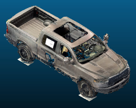
One of the biggest misconceptions is that a point cloud model is simply a group of photos stitched together. While photos may be used as part of the process, a point cloud is built using scanning and/or photogrammetry (measurements from photographs) technology that captures millions of precise data points in three-dimensional space.
That means the result is not just a visual record. It is a measurable digital model of the scene. Instead of seeing only what the camera captured from one angle, users can examine the entire captured environment from different viewpoints and take accurate measurements directly from the model.
A Point Cloud Does Not Decide What Happened
Another common misunderstanding is that a point cloud model tells investigators exactly how a crash occurred. A point cloud does not make conclusions on its own. What it does is preserve the physical details of the crash site so those details can be analyzed more carefully.
This can include vehicle positions, lane widths, roadway markings, guardrails, signs, slopes, and other nearby features. The point cloud provides the data. Professionals still need to interpret that information as part of the larger investigation.
Point Clouds Capture More Than the Vehicles
Some people think point cloud models only focus on damaged vehicles. In reality, they capture much more than that. A point cloud can preserve the wider scene, including the roadway surface, shoulders, intersections, traffic control devices, nearby structures, and other environmental details.
This broader context matters because crashes do not happen in isolation. Roadway geometry, visibility, surface conditions, and surrounding objects can all play a role in what happened.
They Preserve Details That May Not Last
Crash scenes change quickly. Vehicles are moved, debris is cleared, and the weather can alter the roadway. One of the most useful things about a point cloud model is that it creates a lasting digital record of the scene before those details are lost.
This can be especially helpful when accurate measurements or later review are needed. Instead of relying only on memory, notes, or limited photos, investigators have a more complete digital record to work from.
What Point Cloud Models Really Offer
Point cloud models are not just pictures, and they do not replace professional analysis. What they do offer is an accurate, detailed way to preserve a crash scene so important measurements and conditions can be reviewed later. They capture far more than many people realize, making them a valuable part of modern crash documentation.
If you need a better way to preserve and examine crash scene details, 4N6XPRT Systems offers advanced point cloud models and forensic car accident reconstruction software that provides accurate documentation for court, insurance, and technical analysis. Give us a call at (619)464-3478 to learn more about how we can help today.